On Top of the World, in the U.S. and Canada
On a glorious family trip in 2004, we visited the two 'triple divides' among drainage basins in North America. Which is the real hydrological peak? It depends, of course.
Substack writing colleague Brad Delong used his Grasping Reality blog yesterday to highlight one of my favorite sort of map, the kind that depicts the boundaries of water drainage basins. A lot of human history depends on where the waters flow.
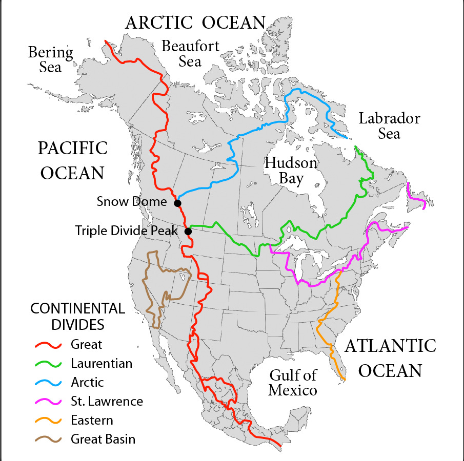
The map Mr. Delong chose, which he borrowed from Wikipedia, is the grandparent of all drainage basin maps in North America. Here it is:
This map shows the principal drainage basins of the North American continent and the continental divides which separate those basins.
Every drop of water falling in North America ends up in the Atlantic Ocean, the Gulf of Mexico, the Great Basin, the Pacific Ocean, the Arctic Ocean, Hudson Bay, and the Great Lakes emptying into the Saint Lawrence River, whose mouth is at the Atlantic.
(Hudson Bay, the Great Lakes/Saint Lawrence, and the Gulf of Mexico are all either arms of the Atlantic Ocean or empty into the Atlantic. The Great Basin has no outlet into any ocean or other basin.)
I bring this up because of the two points highlighted on the map: Triple Divide Peak (8,025 feet) in Glacier National Park, Montana, and Snow Dome (11,339 feet) on the border of Banff and Jasper national parks in Canada. Snow Dome is also on the border of Alberta and British Columbia.
Here’s the great quandary to be considered here:
Both Triple Divide Peak in Montana and Snow Dome on the Alberta-British Columbia border are said to be the hydrological apex of North America.
Which is correct?
In 2004, my family went west by Amtrak’s Empire Builder train to Glacier Park. We spent several days there. We crossed the Atlantic/Pacific Great Divide several times and had a grand view of Triple Divide Peak.
Triple Divide Peak is described as the hydrological apex of North America because three basins meet at its summit: the Pacific watershed, the Atlantic watershed, and the Arctic Ocean watershed — when Hudson Bay is considered part of the Arctic Ocean.

The ridge line between the watersheds of the Atlantic and Arctic oceans — if Hudson Bay is part of the Arctic Ocean — is called the Laurentian Divide. Just to make life more interesting, the Laurentian Divide traverses another triple divide — through not very mountainous at all — near Hibbing, Minnesota, where waters flow three ways to the Great Lakes, the Gulf of Mexico, and Hudson Bay.
In fact, little of the Laurentian Divide is mountainous. Take this Wikipedia photo in Burke County, North Dakota, on the Laurentian Divide. You can barely see it!

Our story continues.
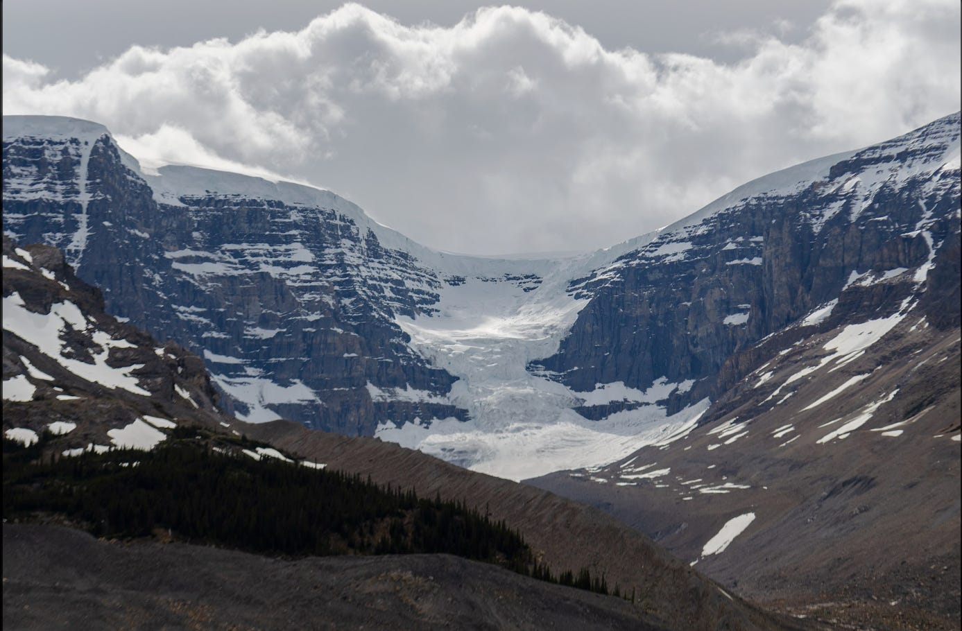
After a few days in Glacier, we rented a minivan and drove across the international border into Canada’s province of Alberta. We stayed in scenic beautiful Canmore near the entrance to Banff National Park. And on a spectacular day, we drove north on the Icefields Parkway to the Columbia Icefield at the foot of Snow Dome.

At Snow Dome, again three watershed basins meet at the summit. Depending on which face of the mountain it might fall, a drop of water can end up in the Pacific Ocean via the Columbia River, in Hudson Bay via the Saskatchewan River, or in the Arctic Ocean via the Athabasca and MacKenzie rivers. If you consider Hudson Bay as part of the Atlantic Ocean, then Snow Dome is the hydrological peak of North America, where the Atlantic/Pacific Great Divide meets the Arctic Divide.
The Columbia Icefield covers the headwaters of the Columbia, Athabasca, and Saskatchewan rivers. It’s an astounding place to visit. You can take an especially equipped bus onto the ice field glacier. As you walk around, you’re standing on a block of ice taller than the Empire State Building. The actual ground is way, way, way down below you. The ice shifts and a safe walking area as well as bus offloading area is marked daily by the staff.

The Columbia Icefield is so remote that it was one of the last places in Canada explored by Europeans. Wikipedia reports:
The Columbia Icefield was one of the last major geological features in western Canada to be visited and recorded by Europeans, due to its isolation and harsh weather conditions. In April 1827, Scottish botanist David Douglas was crossing Athabasca Pass—a major trading route located north of the Icefield—when he climbed one of the adjacent mountain peaks. He reported his first ascent in his journal, describing it to be 6,000 metres (20,000 ft) in height. In the summer of 1884, geology professor Arthur Philemon Coleman explored the Great Divide from Banff to Jasper in search of Douglas' giant peak. While unsuccessful, he did discover the route that would become the Icefield Parkway. In July 1898, British explorer J. Norman Collie and his friends Hugh Stutfield and Herman Wooley set off in search of Douglas' giants, equipped by the famous Banff outfitter Bill Peyto. On the morning of August 18, Collie and Wooley climbed the east side of Mount Athabasca, moved up the glacier when the ridge gave way to crumbling rock, and made their way to the summit, where they discovered an ice field that extended to almost every horizon. Collie later wrote:
“The view that lay before us in the evening light was one that does not often fall to the lot of modern mountaineers. A new world was spread at our feet: to the westward stretched a vast ice-field probably never before seen by the human eye, and surrounded by entirely unknown, unnamed and unclimbed peaks."
And so we are left with the quandary: Which triple peak is the true hydrological peak of North America?
If you’ve read closely, it all depends on whether Hudson Bay is part of the Arctic Ocean or part of the Atlantic Ocean.
When I was growing up, we called it “Hudson’s Bay,” though the apostrophe and the “S” are now eliminated. And we were taught that Hudson Bay emptied into the Atlantic Ocean.
But not so anymore. The International Hydrographic Organization now defines Hudson Bay (without the apostrophe-S) as part of the Arctic Ocean, as it connects with the ocean just north of the Arctic Circle.
So, it is at Triple Divide Peak that waters flow into the Arctic Ocean via Hudson Bay, into the Pacific Ocean via the Columbia River, and into the Atlantic Ocean via the Missouri and Mississippi rivers into the Gulf of Mexico, which is an arm of the Atlantic.
Triple Divide Peak is the hydrological peak of North America.
Snow Dome and the Columbia Icefield are much more spectacular, cold, and remote. The elevation is higher. But as Hudson Bay is part of the Arctic Ocean in these modern times, then the Athabasca and Saskatchewan rivers ultimately feed the same ocean, namely the Arctic. The Columbia may empty into the Pacific Ocean, but only two oceans are served from the Canadian peak, whereas three oceans are served from the U.S. peak.
American Exceptionalism restored.
(For an opposing viewpoint, see this argument by a Canadian travel writer. But it all depends on which ocean you think the Hudson Bay waters flow to.)


