
Looking at Maps and Deciding Where You Really Live

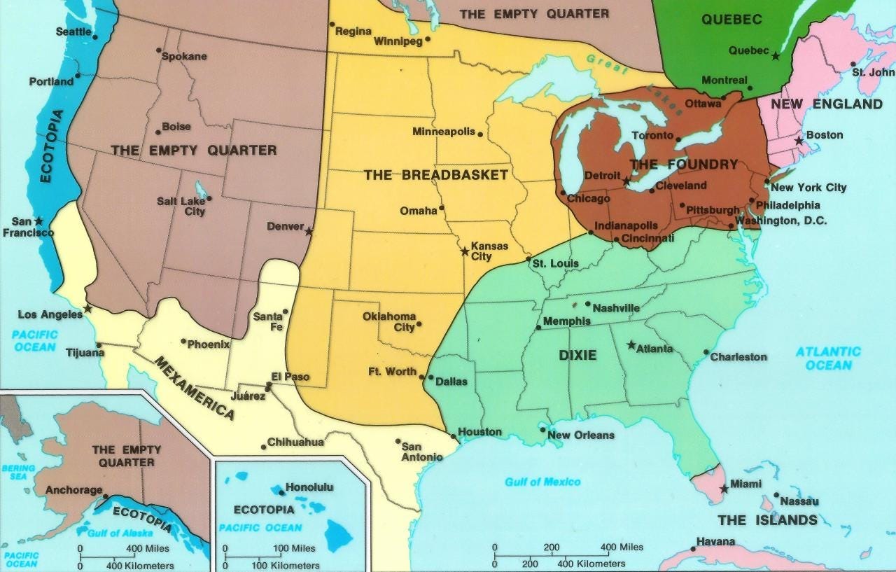
Source: “The Nine Nations of North America,” by Joel Garreau, published in 1981
Anyone who knows me halfway well knows I love geography and I love maps. This article is for people who join me in that interest. We’re going to look at maps of the United States. Ready to argue about them?
One of my favorite questions upon meeting a new person is to ask them where they live. The answer is often illuminating, especially if I ask about a neighborhood of a city or a region of their state or nation.
My interest derives from a San Diego Union-Tribune article published so long ago — in the early- to mid-1980s, I think —that I doubt it can be found on the Internet. In the article, the Union-Tribune attempted to define the myriad neighborhoods of San Diego by asking the experts to draw the lines.
In other words, the newspaper staff interviewed hundreds of people on the streets of the city and asked a simple question: “What neighborhood is this?” The answers were plotted on a map. Perhaps surprisingly, the people on the streets had a different idea about neighborhood boundaries than the planners in City Hall had.
As an Indianapolis News reporter covering metropolitan development at the time, I was fascinated by the San Diego article. I harbored a hope that we might replicate the story in Indianapolis. Another great candidate for such a story might be Chicago, a city of neighborhoods famously 77 strong and often depicted on pop-art maps of the city.
At the time, I was also influenced by a book depicting socio-economic regions of the continent. It was a 1981 book called The Nine Nations of North America, by Joel Garreau. He developed regions that crossed over national boundaries and redrew the continental map. Thanks to its francophone culture, Quebec was the only political or regional subdivision surviving unchanged.
I had moved to Indianapolis two years after Nine Nations was published. Indy was an important city, Garreau explained, because it lies at the intersection of three regions: “The Foundry,” “The Breadbasket” and “Dixie.” While I lived in Indy from 1983 to 2006, I often studied regions of Indiana with Garreau’s analysis in mind. Thus, Southern Indiana was in “Dixie,” focused on Louisville, Kentucky. Western Indiana was in “The Breadbasket,” more like Central Illinois than like Central Indiana. And Indianapolis, Central Indiana, and Northern Indiana were part of “The Foundry.” Not surprisingly, that’s where most of Indiana’s automotive factories and steel mills are located.
Two Indiana cities I frequently visited, Columbus and Lafayette, lay on the border of two regions. Lafayette and its sister city of West Lafayette (home to Purdue University) lies on the border of “The Foundry” and “The Breadbasket.” Columbus, Indiana, lies on the border of “The Foundry” and “Dixie.” Both cities exhibit aspects of each of the their two regions.
Years later, having lived in New England, the Southeast, and the Midwest, I have little disagreement with Nine Nations. It remains a powerful analytic tool for North American geography studies. Canadians and Mexicans might disagree with cross-border regions. But I think they make sense.
(By the way, the West Coast’s “Ecotopia” region was based on the 1975 novel by Ernest Callenbach, Ecotopia: The Notebooks and Reports of William Weston. It suggested that the Northwest Coast from San Francisco north broke away from United States to create a utopian culture based on environmental conservation. In Nine Nations, “Ecotopia” extended up the British Columbia and Alaska coasts to take in Vancouver, Victoria, Juneau, and Anchorage.)
To be candid, I hadn’t thought about this much until I spotted a tweet on Saturday, 7 Nov. 2020, from Atlas Obscura, a website devoted to travel and geography. Strangely, the tweet referred to an article Atlas Obscura published in November 2016 about a study positing new maps and descriptions for metropolitan areas in the United States.
The study, titled “An Economic Geography of the United States: From Commutes to Megaregions,” was written by Garrett Dash Nelson, a historical geographer from Dartmouth College, and Alasdair Rae, an urban analyst from the University of Sheffield, England.
They explored North America through several maps. I am reprinting three of them below.

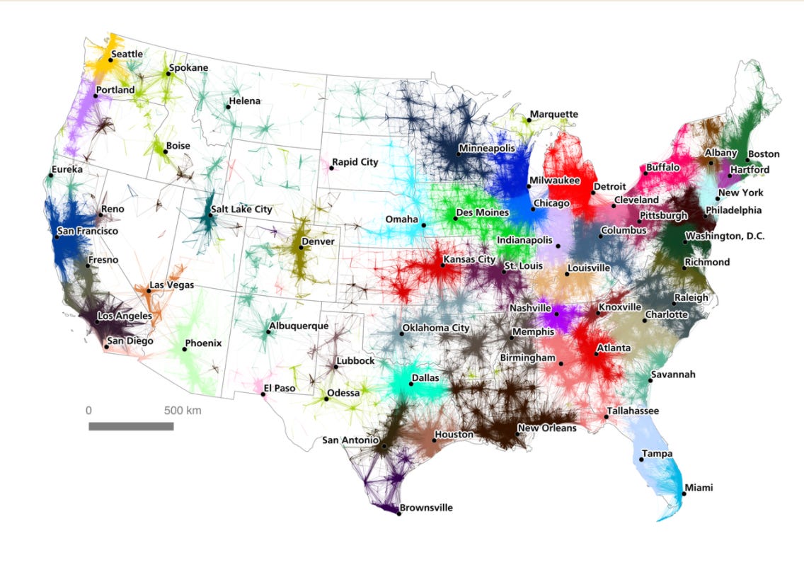

Of all these maps, and the Nine Nations map at the head of this article, I think I like Nine Nations map and the outline map of the metropolitan regions of influence the most. Take a look. Which map makes you feel most at home in your neck of the woods?
The outline map has some problems, however:
The northern third of the Indianapolis region (including the nub extending into southwest Michigan) should be broken off and labeled as “South Bend and Fort Wayne.” Those areas really are separate from Indianapolis. They are their own television and newspaper markets and, significantly, each has a passenger service airport of some (small) size.
I disagree with Vermont being lumped in with New York’s Hudson Valley. First, only a tiny portion of southwest Vermont drains into the Hudson River. Second, Vermont is so very much more like the rest of the map’s “Boston and New England” region than it is like New York State. You can see the Adirondack Mountains from Vermont. But thanks to Lake Champlain, getting to the Adirondacks involves a bridge or a ferry trip. Vermont, to me, is New England. (Burlington, Vermont, is, in a way, another city on the edge of three regions of Nine Nations, as it is not far from the Quebec border. I think Burlington’s airport is the only passenger airport in the United States with signs in two languages: English and French!)
I appreciate, on the other hand, the outline map’s inclusion of the “Connecticut Valley” as a region. The map thus recognizes the importance of the Connecticut River as it ties together a string of cities and towns in Massachusetts and Connecticut (and also in Vermont and New Hampshire). I also note that “Connecticut Valley” includes Fairfield County. I live in Fairfield County and consider myself part of New England. But so many people in Fairfield County orient toward New York City.
The outline map calls a region south of Chicago and west of Indianapolis as the “Corn Belt,” a far more descriptive name than just “Des Moines,” which seems to be the name of the same region in the color map.
There’s a sort of literal “empty quarter” (to use a Nine Nations name) in the outline map — a region of the western U.S. without any name. I’d label it as “Western U.S.” or, even better, as “Intermountain & West.”
Could the “Deep South” be renamed as “Birmingham?” Probably not. This is a region of small cities: Birmingham and Montgomery in Alabama, Columbus and Albany in Georgia, and Tallahassee in Florida. I’d like a name other than “Deep South,” which strikes me as anachronistic. But I am not now sure what to propose.
I hope you have enjoyed this exploration of maps and geography.